Main menu
You are here
OruxMaps Donate
User login
<p><br /> ATTENTION, THIS IS THE VERSION 'DONATE'. IF YOU WANT, YOU CAN TRY THE FREE VERSION, WHICH IS IDENTICAL TO THIS.</p>
<br />
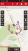
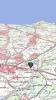
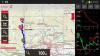
<p><br /> Map viewer/route logger for your outdoor activities.<br /><br /> OruxMaps works in two modes:<br /><br /> -online with many different types of maps (Google maps, OpenStreetMap, Microsoft Maps,etc.).<br /><br /> -offline with calibrated maps for the application. You can convert your Ozi Explorer maps, or create your own maps, with a desktop tool.<br /><br /> Allows you record tracks using GPS. It works with gpx and kml formats.</p>
<br />
<p><br /> More features:</p>
<br />
<p><br /> 100% free<br /><br /> 100% no Advertising</p>
<br />
<p><br /> Map download</p>
<br />
<p><br /> 3D view</p>
<br />
<p><br /> Text to Speech (some locales)</p>
<br />
<p><br /> Wms support<br /><br /> Support to some .rmap maps<br /><br /> Support to vector maps (mapsforge)<br /><br /> Support to vector Garmin .img maps (not locked)</p>
<br />
<p><br /> Profiles<br /><br /> Save/restore preferences</p>
<br />
<p><br /> Complete track statistics, with different graphs</p>
<br />
<p><br /> External bluetooth GPS support</p>
<br />
<p><br /> Export your tracks in KML/GPX/KMZ formats</p>
<br />
<p><br /> Follow your old tracks/routes, with distance alarm.</p>
<br />
<p><br /> Save Waypoints with attached photo-audio-video media files. Wpt proximity alarm with custom audio alarm</p>
<br />
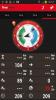
<p><br /> Waypoint navigation mode</p>
<br />
<p><br /> Geocaching support</p>
<br />
<p><br /> Custom cursor images</p>
<br />
<p><br /> Power save mode, for long track recording</p>
<br />
<p><br /> Use a heart monitor with your device (supported Zephyr HRM, Polar Bluetooth and ANT+)</p>
<br />
<p><br /> Upload/download tracks from everytrail.com<br /><br /> Upload tracks to gpsies.com, mapmytracks.com and trainingstagebuch.org<br /><br /> Live tracking with mapmytracks.com</p>
<br />
<p><br /> More info here: www.oruxmaps.com</p>
<br />