Main menu
You are here
MyTrails
User login
<p><br /> ★ No ads even in the free version!</p>
<br />
<p><br /> ★ Premium topo maps<br /><br /> Use in-app purchases to subscribe to high-quality, special-purpose maps. Flexible offline mode and competitive pricing.<br /><br /> • Ordnance Survey 25k and 50k (GB)<br /><br /> • OS OpenData (GB)<br /><br /> • IGN TOP25, TOP50 and Cadastre (FR)<br /><br /> • Tour & Trail (Alpujarras, Axarquia, Costa Blanca, La Gomera, Lanzarote, La Palma, Madeira, Mallorca, Menorca, Sierra de Aracena, Tenerife)</p>
<br />
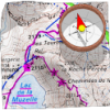
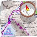
<p><br /> ★ Full-screen trail map oriented with the built-in compass<br /><br /> Know exactly which direction you are going.<br /><br /> Uncluttered map area, with unobtrusive controls and a traditional scale with track duration and distance.</p>
<br />
<p><br /> ★ OpenGL Rendering<br /><br /> Hardware-accelerated map drawing allows smooth and snappy display even with tens of thousands of track points.</p>
<br />
<p><br /> ★ Free online maps<br /><br /> Pick from many built-in online map sources (OpenStreetMap, Yahoo, Bing, Google and many other global and local providers).<br /><br /> Add more map sources using the configurable map sources (URL or WMS).<br /><br /> Only premium maps are guaranteed: we may be forced to remove access to any of the other maps if requested by the rights-holders; this is regardless of whether you are using the Pro or Free version.</p>
<br />
<p><br /> ★ Offline maps<br /><br /> Save battery and data charges.<br /><br /> The map displays instantaneously.<br /><br /> Optionally falls back to online for non-covered areas.</p>
<br />
<p><br /> ★ Offline map creation<br /><br /> No need to use desktop-based tools to create offline maps, you can do it in MyTrails, in the background.<br /><br /> Pause and resume the tile download.<br /><br /> Download on WiFi only to save data charges.</p>
<br />
<p><br /> ★ Record GPS tracks<br /><br /> Visualize your track at any time and analyse your course during or after the outdoor activity.</p>
<br />
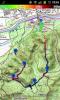
<p><br /> ★ Display multiple GPS tracks at once<br /><br /> Visualize your previous outings and those uploaded to GPS community sites, so that you always pick a great trail.</p>
<br />
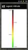
<p><br /> ★ Colorized tracks<br /><br /> Visualize the key indicators of the track (altitude, speed, rate of ascent, slope, GPS accuracy) right on the map with a detailed legend.</p>
<br />
<p><br /> ★ Directions<br /><br /> Get visual directions from point A to point B.<br /><br /> Vibrate, ring or spoken proximity notifications warn you of upcoming manoevers.</p>
<br />
<p><br /> ★ Waypoints<br /><br /> Manually add waypoints to indicate memorable spots or upcoming turns.<br /><br /> Waypoints are automatically generated when getting directions or when you take a break.</p>
<br />
<p><br /> ★ Share and archive tracks<br /><br /> Share your tracks on My Trails or GPSies.<br /><br /> Download tracks shared by other users in your vicinity.</p>
<br />
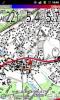
<p><br /> ★ Gestures<br /><br /> Easily switch between active maps by swiping three fingers left to right in the map view.<br /><br /> Pull down the HUD with information on your speed and altitude by swiping three fingers down your screen.</p>
<br />
<p><br /> ★ Full tablet support<br /><br /> Plan your outing on a large-screen tablet, go out and have fun, and when you're back, view the track in full glory. Use Dropbox to seamlessly synchronize between devices.</p>
<br />
<p><br /> ★ MyBackup Integration Support<br /><br /> Easy back and restore of MyTrails data for rooted and non-rooted devices</p>
<br />
<p><br /> FAQ: <a href="http://www.google.com/url?q=http://www.frogsparks.com/wordpress/category... target="_blank">http://www.frogsparks.com/wordpress/category/faq/</a></p>
<br />
<p><br /> Permissions: please see the FAQ</p>
<br />